Creative Space: Jo Hannah Asetre


Growing up I’ve always felt conflicted when asked what my dream job was, as someone who enjoys and is interested in both art and the sciences.
I wanted to do and study many things and found it difficult to just pick one to focus on. What I am sure of is that no matter what field I venture into, I want to design as a means to inform, communicate, and educate, at the core of what I do. Studying and understanding nature through art has always been a huge passion and driving force for me. I suppose right now I am working my way towards making that come true, by pursuing a career in geoscience research and science communication.
What is your ideal work routine? What does a good day look like?
I’m a bit of a weird hybrid by being both a morning person and a night owl. The time of day when I feel most productive varies a lot, but I keep the strict rule of doing work on my desk and keeping it tidy. That critical part between brainstorming a project and tangibly starting it is usually the hardest hurdle, but once I get in that zone of actually doing the work, I find it really hard to stop until I feel like I have finished something worthwhile with it.
While every day is a bit different for me as I study full time and work part-time as a graphic designer, my ideal day would start with me getting up early to go for a morning run, and getting back with a warm cup of coffee to get the brain juices flowing. Work days usually go by quickly, but in between those I’m happy to still have time to breathe. I consider one to be a good day as long it has enough balance between work and play, I successfully ticked off all points on my to-do list, and I was able to learn something new.

For days when you lack drive/motivation, how do you get unstuck?
I’ve made peace with the fact that as a creative, there really will be days when you can’t help but compare yourself to others, and even berate yourself for not being productive enough. Social media typically is the main culprit in this, and even if it is difficult to commit to at times, taking a break from the online world is a genuinely helpful way to recalibrate and refocus.
I allow myself to take a break by watching a new episode of a series I’ve been following, continuing to read that one book that’s perpetually on my bedside table, finishing a module on a free online course, searching for new recipes to try, and browsing through information design and visual data websites to get inspired with new ideas. Other times, I step away from the screen to play songs with my ukulele, have a calming afternoon tea, and go outside for a brief walk/run to get some fresh air. I also currently live alone in a different country, so having that quick catch-up (though at times it lasts for hours) video call with my family and friends back home helps me get back on track.

What fascinated you the most about maps?
I consider myself a visual learner, and with that I’ve always been interested in getting to know a place by looking at its qualities through a broader and intrinsically layered view. Maps give us a different perspective, and coupled with the right information, these can deepen our understanding of the spaces we foster a connection with.
As a kid, I remember being thoroughly fascinated with Google Earth and would spend hours on end looking up the town where I live, pointing at our house, and searching the cities where my relatives have lived in the US and Europe. I remember having all these world and Philippine maps they used to require for us to have in grade school, memorizing the different islands and provinces, and their respective capitals. Growing up, this transcended into being a lover of the outdoors and travelling around the country.
The way I see it, maps are a distinct form of storytelling. Depending on what you’d like to show and understand, one can closely examine a specific area’s fascinating qualities, show spatial correlations, and even study how places have changed through time, among others— all in a single visual piece.
I am a big fan and closely follow the compelling works of map designers like Paula Scher, Eleanor Lutz, and David Garcia. From sloping coasts to jagged mountains, magnificent volcanoes to sprawling cities, map representations offer a wider scope than what can be seen on ground. It shows us that these landscapes are deeply interconnected in more ways than one.
What was the process like?
Lots of research and self-learning! While I’m no expert, I do have a fair bit of knowledge on GIS, map features, and map design. Thankfully, there are various open-source data out there and the process of rendering a map is pretty much done digitally now through GIS and design softwares. (It’s both amazing and crazy to think that geographers and cartographers used to draw and paint all of this by hand!)
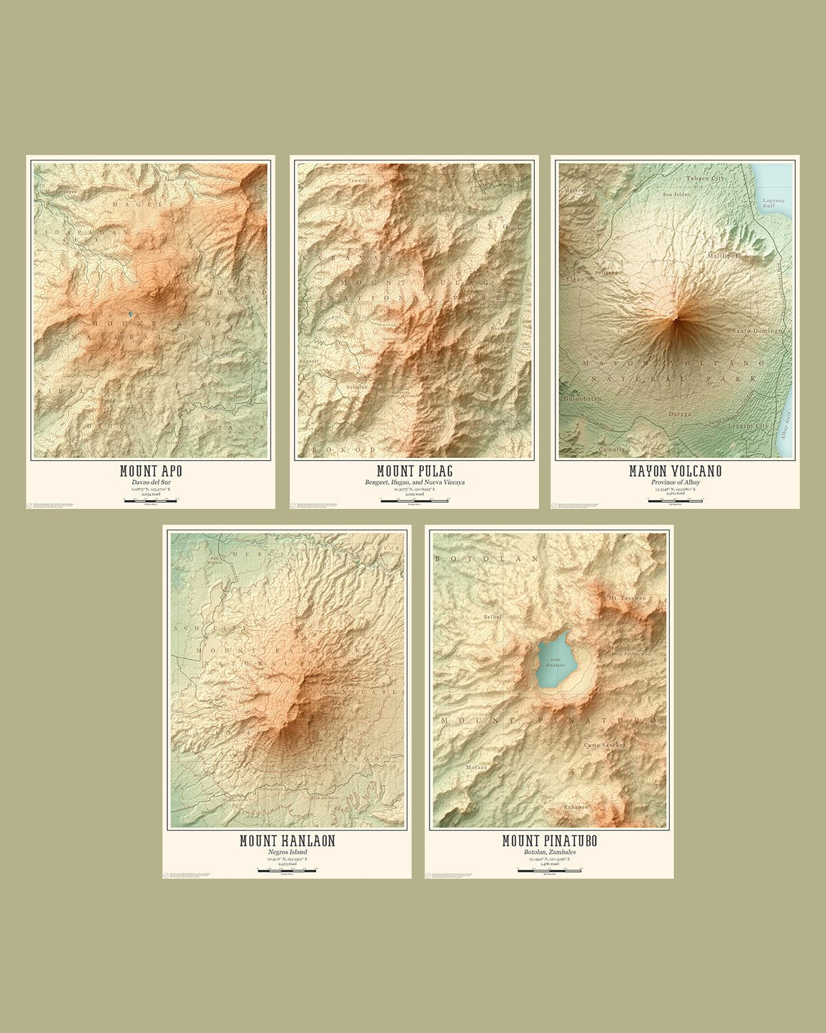
With this project, I wanted to explore and show the depth of geography and beautiful terrains of our Philippine mountains through this kind of visualization. Working on these maps also allowed for some inward contemplation, and a more profound appreciation of these landscapes.
Our iconic mountains are vital features of our land. They serve as barriers to protect us from drastic impacts of typhoons, supply freshwater to communities, provide a home to thousands of plant and animal species, and inspire us with their raw and breathtaking beauty. Throughout the research and design process, It was also a lot of fun to learn more interesting facts about these mountains, like how Mayon Volcano is geographically subdivided into eight different towns and cities akin to pizza slices, and how Mount Apo serves as a sanctuary to over 100 endemic bird species!
Being away from the country, I guess this became a way to remind myself of home and keep true to my roots. In this current situation, I hope these maps remind people of the mountains they’ve reached and their associated memories with it, be their bucket list for peaks they have yet to conquer, and serve as motivation for the wonders and awe-inspiring sceneries that are out there for them to explore once everything turns for the better. Like many people right now, I long for the time when we can freely explore the outdoors once again and enjoy tranquil moments within natural landscapes. In retrospect, doing these maps have sort of been a proxy for me to survey these mountains and virtually go back home, albeit just doing it on my laptop screen.
What drives you to do your work? What are you trying to change?
We live in a crucial time where natural landscapes are being threatened and environmental threats are imminent. It motivates me to create content that can promote awareness of the natural environment, and public understanding of earth science processes. I believe that science, education, and storytelling are vital aspects in this.
By exploring the features of our lands, forests, and seas, we can understand the conditions that forged them into what they are now, and hold the key to understanding our planet’s future. Right now, I’m still currently forging my way towards making impactful contributions in the field, but championing sustainable tourism, active conservation, and protecting wildlife and sites of geological importance are some of the causes I hold close to heart. Be it through making relief maps, designing infographic pieces, or photographing natural landscapes, I aspire to promote appreciation of our world’s wonders, impart knowledge about how these places have nurtured us, and how we must care for it in return.
Is this still relevant for today? Or have things changed? What I’m curious about is how this will carry out, like what will the trend be for this type of stuff about online communication courses free philippines ?
Shared! This is AWESOME stuff about online communication courses free philippines! Thank you!
Great story and amazing pictures. Thank you very much for sharing. Check detail about the Everest base camp trek.
Great story and amazing pictures. Thank you very much for sharing. Check detail about the <a =“https://www.frolicadventure.com”>Everest base camp trek.
Leave a comment